South Korea: Difference between revisions
imported>Chunbum Park m (→Climate) |
mNo edit summary |
||
| (16 intermediate revisions by 5 users not shown) | |||
| Line 1: | Line 1: | ||
{{subpages}} | {{subpages}} | ||
{{ | |||
'''South Korea''', officially the '''Republic of Korea''' or '''ROK''' ([[Korean]]: ''Namhan''; ''Daehan Min-guk''<ref>i.e. 'Great Han people's nation'</ref> | {{Infobox Country | ||
| conventional_long_name = Republic of Korea<br/>대한민국 | |||
| common_name = South Korea | |||
| image_flag = Flag_of_South_Korea.svg | |||
| image_coat = Emblem_of_South_Korea.svg | |||
| national_anthem = Aegukga | |||
| image_map = South Korea Base Map.png | |||
| capital = [[Seoul]] | |||
| largest_city = Seoul | |||
| official_languages = Korean, Korean Sign Language | |||
| government_type = Unitary presidential republic | |||
| leader_title1 = President | |||
| leader_name1 = Yoon Suk Yeol | |||
| leader_title2 = Prime Minister | |||
| leader_name2 = Han Duck-soo | |||
| area = | |||
| areami² = | |||
| population_estimate = | |||
| population_estimate_rank = | |||
| population_estimate_year = | |||
| population_density = | |||
| population_density_rank = | |||
| population_densitymi²= | |||
| currency = Korean Republic won (₩) | |||
| currency_code= KRW | |||
| HDI = | |||
| HDI_category = | |||
| HDI_rank = | |||
| HDI_year = | |||
| time_zone = UTC | |||
| utc_offset = +9 | |||
| time_zone_DST = | |||
| utc_offset_DST = | |||
| cctld = .kr | |||
| calling_code = 82 | |||
}} | |||
'''South Korea''', officially the '''Republic of Korea''' or '''ROK''' ([[Korean]]: ''Namhan''; ''Daehan Min-guk''<ref>i.e. 'Great Han people's nation'</ref><ref name="romanization">According to the [[revised romanization of Korean]].</ref>), is a constitutional republic comprising the southern part of [[Korea]], which protrudes southward from the Northeastern Asian mainland and lies between the [[Yellow Sea]] and the [[Sea of Japan|East Sea]]. It is historically and culturally related to its [[East Asia|East Asian]] neighbors including China, [[Taiwan]], and [[Japan]]. When South Korea was established in 1948 after the end of [[Japanese Occupation of Korea|Japanese colonial rule]], the country was one of the poorest in the world, and its economic prospect worsened with destruction of the nation's infrastructure during the [[Korean War]] from 1950 to 1953. However, during the the early 1960s and the two decades that followed, South Korea transformed its largely agricultural economy into a modern industrial power and has currently the 15th largest [[GDP]]. South Korea's capital is [[Seoul]], one of the world's 10 largest cities<ref name="seoulsize">[http://www.korea.net/korea/kor_loca.asp?code=W05 Exploring Korea], Korea.net, date accessed: 2009-01-08.</ref> and a major technological and financial hub in the region. The country's current president is [[Park Geunhye]], who assumed office in February 2013. | |||
{{Image|Namdaemun at night.jpg|right|350px|The [[Namdaemun]] Gate in Seoul, a [[World Heritage]] site designated by [[UNESCO]], was destroyed by arson in 2008.}} | {{Image|Namdaemun at night.jpg|right|350px|The [[Namdaemun]] Gate in Seoul, a [[World Heritage]] site designated by [[UNESCO]], was destroyed by arson in 2008.}} | ||
| Line 8: | Line 45: | ||
{{Image|Political map of the Korean peninsula.gif|left|175px|A political map of Korea.}} | {{Image|Political map of the Korean peninsula.gif|left|175px|A political map of Korea.}} | ||
=== Physical constituency === | === Physical constituency === | ||
South Korea covers a total of 99,268 km<sup>2</sup> (38,328 mi<sup>2</sup>) over eight mainland provinces, the [[Jejudo|Jeju Island]], and approximately 3,000 smaller islands appearing almost entirely on the western side of the peninsula. By comparison, the country is slightly larger than the U.S. state of [[Indiana]] and is about 4/5th the size of [[North Korea]]. | South Korea covers a total of 99,268 km<sup>2</sup> (38,328 mi<sup>2</sup>) over eight mainland provinces, the [[Jejudo|Jeju Island]], and approximately 3,000 smaller islands appearing almost entirely on the western side of the peninsula. By comparison, the country is slightly larger than the U.S. state of [[Indiana (U.S. state)|Indiana]] and is about 4/5th the size of [[North Korea]]. | ||
South Korea is largely mountainous, with only 30% of its terrain being the lowlands, concentrated mostly on the western and the southeastern parts of the country.<ref name="encarta">"[http://encarta.msn.com/encyclopedia_761562354/south_korea.html South Korea]," Microsoft Encarta Online Encyclopedia 2008.</ref> Along the curve of the eastern coastline, the [[Taebaek Mountains]], the northern end of which originates in North Korea, run in the north-south direction.<ref name="britannica">"[http://school.eb.com/all/eb/article-9108457 Korea, South]." ''Encyclopædia Britannica'', date accessed: 2008-11-10.</ref> Four smaller mountain ranges branch off south-westward from the Tabaek Mountains, and the largest among them, the [[Sobaek Mountains|Sobaek range]], makes a long S-shape that divides the southern region. The highest points of these are [[Mount Jiri]] in the Sobaek Mountains, reaching a height of 1,915 m (6,283 ft), and [[Mount Sorak]] in the Taebaek range, peaking at 1,708 m (5,604 ft), but none are as high as [[Mount Halla]], which is an extinct volcano with a height of 1,950 m (6,398 ft). It is located on the southern island of Jejudo, which is the country's largest island. | South Korea is largely mountainous, with only 30% of its terrain being the lowlands, concentrated mostly on the western and the southeastern parts of the country.<ref name="encarta">"[http://encarta.msn.com/encyclopedia_761562354/south_korea.html South Korea]," Microsoft Encarta Online Encyclopedia 2008.</ref> Along the curve of the eastern coastline, the [[Taebaek Mountains]], the northern end of which originates in North Korea, run in the north-south direction.<ref name="britannica">"[http://school.eb.com/all/eb/article-9108457 Korea, South]." ''Encyclopædia Britannica'', date accessed: 2008-11-10.</ref> Four smaller mountain ranges branch off south-westward from the Tabaek Mountains, and the largest among them, the [[Sobaek Mountains|Sobaek range]], makes a long S-shape that divides the southern region. The highest points of these are [[Mount Jiri]] in the Sobaek Mountains, reaching a height of 1,915 m (6,283 ft), and [[Mount Sorak]] in the Taebaek range, peaking at 1,708 m (5,604 ft), but none are as high as [[Mount Halla]], which is an extinct volcano with a height of 1,950 m (6,398 ft). It is located on the southern island of Jejudo, which is the country's largest island. | ||
| Line 26: | Line 63: | ||
South Korea has a temperate continental climate with four distinct seasons. Its summers are very hot and humid, and its winters very cold and dry, due to the combined influences of the Asian mainland and the the northeast Asian [[monsoon|wind system]]. During winter, the dry Arctic air is brought in by the Asian monsoon, which reverses direction and carries the hot, humid air from the [[South China Sea]] during the rainy summer. Spring and autumn are pleasant but short. | South Korea has a temperate continental climate with four distinct seasons. Its summers are very hot and humid, and its winters very cold and dry, due to the combined influences of the Asian mainland and the the northeast Asian [[monsoon|wind system]]. During winter, the dry Arctic air is brought in by the Asian monsoon, which reverses direction and carries the hot, humid air from the [[South China Sea]] during the rainy summer. Spring and autumn are pleasant but short. | ||
The warmest month in South Korea is August | The warmest month in South Korea is August, which has an average temperature of 25 °C (77 °F). In contrast to the relatively unvarying distribution of heat during summer, there is a noticeable difference in temperature between the northern and southern parts of the country in winter. For example, in the coldest month, January, the average temperature ranges from -5 °C (23 °F) in Seoul to 2 °C (35 °F) in the southern port city of [[Busan]]. | ||
On the mainland, the annual precipitation ranges from about 900 to 1,500 mm (35 to 60 in), much of which occurs during the summer as typhoons and heavy rains. Flooding occurs in some parts of the country due to the increased precipitation and river flow. In the very southern parts of the country, however, rainfall tends to be more consistent throughout the year. In Jeju Island, the annual precipitation is around 1,800 mm (70 in). Two or three typhoons are expected annually, though Korea's typhoons tend to have less impact than those in neighboring countries such as Japan, Taiwan, and eastern China.<ref name="encarta"/><ref name="britannica"/><ref name="library of congress climate">[http://countrystudies.us/south-korea/31.htm "Climate"], Savada and Shaw, 1990. ''South Korea: A Country Study'', US Library of Congress.</ref><ref name="junior">"[http://www.encyclopedia.com/doc/1G2-3425900152.html Korea, South]." Junior Worldmark Encyclopedia of Physical Geography. The Gale Group, Inc. 2003. ''Encyclopedia.com''. 29 Apr. 2009 <nowiki><</nowiki>[http://www.encyclopedia.com http://www.encyclopedia.com]<nowiki>></nowiki>.</ref><ref name="forestclimate">[http://english.forest.go.kr/foahome/user.tdf?a=common.HtmlApp&c=1006&page=/html/eng/korea/peninsula/peninsula_020_010.html&mc=ENG_KOREA_PENINSULA_020 Climate], Korea Forest Service, date accessed: 2009-04-30.</ref> | On the mainland, the annual precipitation ranges from about 900 to 1,500 mm (35 to 60 in), much of which occurs during the summer as typhoons and heavy rains. Flooding occurs in some parts of the country due to the increased precipitation and river flow. In the very southern parts of the country, however, rainfall tends to be more consistent throughout the year. In Jeju Island, the annual precipitation is around 1,800 mm (70 in). Two or three typhoons are expected annually, though Korea's typhoons tend to have less impact than those in neighboring countries such as Japan, Taiwan, and eastern China.<ref name="encarta"/><ref name="britannica"/><ref name="library of congress climate">[http://countrystudies.us/south-korea/31.htm "Climate"], Savada and Shaw, 1990. ''South Korea: A Country Study'', US Library of Congress.</ref><ref name="junior">"[http://www.encyclopedia.com/doc/1G2-3425900152.html Korea, South]." Junior Worldmark Encyclopedia of Physical Geography. The Gale Group, Inc. 2003. ''Encyclopedia.com''. 29 Apr. 2009 <nowiki><</nowiki>[http://www.encyclopedia.com http://www.encyclopedia.com]<nowiki>></nowiki>.</ref><ref name="forestclimate">[http://english.forest.go.kr/foahome/user.tdf?a=common.HtmlApp&c=1006&page=/html/eng/korea/peninsula/peninsula_020_010.html&mc=ENG_KOREA_PENINSULA_020 Climate], Korea Forest Service, date accessed: 2009-04-30.</ref> | ||
| Line 32: | Line 69: | ||
=== Natural environment === | === Natural environment === | ||
{{Image|White Crane At Suncheon Wetlands.jpg|right|300px|A white crane at the Suncheon Protected Wetlands.}} | {{Image|White Crane At Suncheon Wetlands.jpg|right|300px|A white crane at the Suncheon Protected Wetlands.}} | ||
The country's rapid industrialization and high population density have taken a severe toll on the environment. The traditional use of wood as a fuel and building material has gradually led to the clearing of much of the old-growth forests throughout the past centuries. Although today South Korea's temperate forests cover about 65% of the land largely due to the extensive reforestation efforts since the 1970s, the natural ecosystem is small and fragile due to its close proximity to human activities.<ref name="percentcovered">[http://english.forest.go.kr/foahome/user.tdf?a=common.HtmlApp&c=1006&page=/html/eng/korea/peninsula/peninsula_010_010.html&mc=ENG_KOREA_PENINSULA_010 Geography], Korea Forest Service, date accessed: 2009-02-08.</ref> The 4% of the land that is protected as nature reserves is visited annually by millions seeking refuge from the urban areas, and conservation efforts by the government continue to be insufficient in terms of both size and scientific approach.<ref name=" | The country's rapid industrialization and high population density have taken a severe toll on the environment. The traditional use of wood as a fuel and building material has gradually led to the clearing of much of the old-growth forests throughout the past centuries. Although today South Korea's temperate forests cover about 65% of the land largely due to the extensive reforestation efforts since the 1970s, the natural ecosystem is small and fragile due to its close proximity to human activities.<ref name="percentcovered">[http://english.forest.go.kr/foahome/user.tdf?a=common.HtmlApp&c=1006&page=/html/eng/korea/peninsula/peninsula_010_010.html&mc=ENG_KOREA_PENINSULA_010 Geography], Korea Forest Service, date accessed: 2009-02-08.</ref> The 4% of the land that is protected as nature reserves is visited annually by millions seeking refuge from the urban areas, and conservation efforts by the government continue to be insufficient in terms of both size and scientific approach.<ref name="choesunilboenvironnational">[http://english.chosun.com/w21data/html/news/200007/200007020192.html Korea's National Parks: Disgrace to Nature Conservation], Chosun Ilbo, 2000-07-2.</ref> | ||
The country's | The country's forests contain some 4,500 species of plants and can be categorized into two types: the Central Korean deciduous forests and the Southern Korea evergreen forests. The Central Korean deciduous forests occupy the northern two-thirds of South Korea (and also much of North Korea) and consist mostly of hardwood trees such as maples, oaks, and hornbeams. A smaller population of conifers is found in areas that are especially cold or have been recently disturbed.<ref name="britannica"/><ref name="earth1">World Wildlife Fund (Content Partner); Mark McGinley (Topic Editor). 2007. "Cntral Korean deciduous forests." In: Encyclopedia of Earth. Eds. Cutler J. Cleveland (Washington, D.C.: Environmental Information Coalition, National Council for Science and the Environment). <nowiki>[</nowiki>Published in the Encyclopedia of Earth April 19, 2007; Retrieved April 29, 2009<nowiki>]</nowiki>. <nowiki><</nowiki>[http://www.eoearth.org/article/Central_Korean_deciduous_forests http://www.eoearth.org/article/Central_Korean_deciduous_forests]<nowiki>></nowiki></ref><ref name="earth2">World Wildlife Fund (Content Partner); Mark McGinley (Topic Editor). 2008. "Central Korean deciduous forests." In: Encyclopedia of Earth. Eds. Cutler J. Cleveland (Washington, D.C.: Environmental Information Coalition, National Council for Science and the Environment). <nowiki>[</nowiki>First published in the Encyclopedia of Earth April 13, 2007; Last revised August 25, 2008; Retrieved May 1, 2009<nowiki>]</nowiki>. <nowiki><</nowiki>[http://www.eoearth.org/article/Southern_Korea_evergreen_forests http://www.eoearth.org/article/Southern_Korea_evergreen_forests]<nowiki>></nowiki></ref> | ||
| Line 48: | Line 85: | ||
== Footnotes == | == Footnotes == | ||
{{reflist}} | {{reflist}}[[Category:Suggestion Bot Tag]] | ||
Latest revision as of 11:01, 20 October 2024
| Republic of Korea 대한민국 | |
|---|---|

| |
 
| |
| National anthem | Aegukga |
| Capital | Seoul |
| Largest city | Seoul |
| Official language | Korean, Korean Sign Language |
| Government type | Unitary presidential republic |
| President | Yoon Suk Yeol |
| Prime Minister | Han Duck-soo |
| Currency | Korean Republic won (₩) (KRW) |
| Time zone | UTC (UTC+9) |
| Country codes | Internet TLD : .kr Calling code : +82 |
South Korea, officially the Republic of Korea or ROK (Korean: Namhan; Daehan Min-guk[1][2]), is a constitutional republic comprising the southern part of Korea, which protrudes southward from the Northeastern Asian mainland and lies between the Yellow Sea and the East Sea. It is historically and culturally related to its East Asian neighbors including China, Taiwan, and Japan. When South Korea was established in 1948 after the end of Japanese colonial rule, the country was one of the poorest in the world, and its economic prospect worsened with destruction of the nation's infrastructure during the Korean War from 1950 to 1953. However, during the the early 1960s and the two decades that followed, South Korea transformed its largely agricultural economy into a modern industrial power and has currently the 15th largest GDP. South Korea's capital is Seoul, one of the world's 10 largest cities[3] and a major technological and financial hub in the region. The country's current president is Park Geunhye, who assumed office in February 2013.
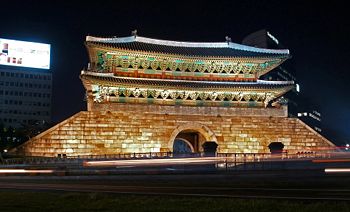
The Namdaemun Gate in Seoul, a World Heritage site designated by UNESCO, was destroyed by arson in 2008.
Geography
Physical constituency
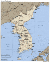
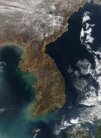
South Korea covers a total of 99,268 km2 (38,328 mi2) over eight mainland provinces, the Jeju Island, and approximately 3,000 smaller islands appearing almost entirely on the western side of the peninsula. By comparison, the country is slightly larger than the U.S. state of Indiana and is about 4/5th the size of North Korea.
South Korea is largely mountainous, with only 30% of its terrain being the lowlands, concentrated mostly on the western and the southeastern parts of the country.[4] Along the curve of the eastern coastline, the Taebaek Mountains, the northern end of which originates in North Korea, run in the north-south direction.[5] Four smaller mountain ranges branch off south-westward from the Tabaek Mountains, and the largest among them, the Sobaek range, makes a long S-shape that divides the southern region. The highest points of these are Mount Jiri in the Sobaek Mountains, reaching a height of 1,915 m (6,283 ft), and Mount Sorak in the Taebaek range, peaking at 1,708 m (5,604 ft), but none are as high as Mount Halla, which is an extinct volcano with a height of 1,950 m (6,398 ft). It is located on the southern island of Jejudo, which is the country's largest island.
The three major rivers in South Korea are the Han, Geum, and Nakdong, all of which originate from the Taebaek range. The Han River is where the capital is situated, and it is the second largest in South Korea. The Han and Geum rivers drain into the Yellow Sea, and the Nakdong River, the longest river in South Korea, empties south into the Korea Strait. Similarly, most of the other fluvial channels in the country also run westward into or southward into the two seas.
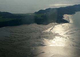
The country's coastline extends 2,413 km (approximately 1,500 mi)[6]. The southern and western coasts differ greatly from the rockier eastern coast in that they are arranged intricately with harbors and islands, whereas the eastern coastline is smooth and simple.[4] Likewise, the tidal ranges vary significantly; on the east side, tides reach only 0.3 m, but the tidal range increases gradually along the south coast and peaks at 910 m (one of the world's highest) in the Gyeonggi Bay in the northwest. Because the western and southern coasts also are relatively flat, extensive and wide tidal flats have formed in these parts from the sediments dumped by the Korean rivers and the Yellow and Yangtze rivers in China. Mud and silt are typical of the tidal flats in the north, in contrast to the sandier texture of the mudflats in the southwest.[7]
The soil, about two-thirds of which formed in the Cenozoic Era, is made up mostly of gneiss and granite. The predominant soil type is brown, but there are regional variations. Red and yellow soils are other major types that are common in the southwest; dark red and grayish brown (podzolic) are found in the southeastern parts of the country. Due to the extreme summer-winter temperatures and the heavy downpour during the summer monsoon season, the soil is well-leached with very little humus content, and it is quite susceptible to erosion.[8][9]
Unlike Japan or the northern provinces of China, the Korean peninsula is geologically stable.[10] There have been no major earthquakes in Korea, and the last volcanic activity on Mount Halla was recorded during the Goryeo Dynasty (also spelled as "Koryo"), from which Korea's modern English name originates. The other group of volcanic islands in the East Sea, Ulleungdo and Dokdo (Liancourt Rocks), were active 2.5 and 4.6 million years ago, respectively.[11]
Climate
South Korea has a temperate continental climate with four distinct seasons. Its summers are very hot and humid, and its winters very cold and dry, due to the combined influences of the Asian mainland and the the northeast Asian wind system. During winter, the dry Arctic air is brought in by the Asian monsoon, which reverses direction and carries the hot, humid air from the South China Sea during the rainy summer. Spring and autumn are pleasant but short.
The warmest month in South Korea is August, which has an average temperature of 25 °C (77 °F). In contrast to the relatively unvarying distribution of heat during summer, there is a noticeable difference in temperature between the northern and southern parts of the country in winter. For example, in the coldest month, January, the average temperature ranges from -5 °C (23 °F) in Seoul to 2 °C (35 °F) in the southern port city of Busan.
On the mainland, the annual precipitation ranges from about 900 to 1,500 mm (35 to 60 in), much of which occurs during the summer as typhoons and heavy rains. Flooding occurs in some parts of the country due to the increased precipitation and river flow. In the very southern parts of the country, however, rainfall tends to be more consistent throughout the year. In Jeju Island, the annual precipitation is around 1,800 mm (70 in). Two or three typhoons are expected annually, though Korea's typhoons tend to have less impact than those in neighboring countries such as Japan, Taiwan, and eastern China.[4][5][12][13][14]
Natural environment
The country's rapid industrialization and high population density have taken a severe toll on the environment. The traditional use of wood as a fuel and building material has gradually led to the clearing of much of the old-growth forests throughout the past centuries. Although today South Korea's temperate forests cover about 65% of the land largely due to the extensive reforestation efforts since the 1970s, the natural ecosystem is small and fragile due to its close proximity to human activities.[15] The 4% of the land that is protected as nature reserves is visited annually by millions seeking refuge from the urban areas, and conservation efforts by the government continue to be insufficient in terms of both size and scientific approach.[16]
The country's forests contain some 4,500 species of plants and can be categorized into two types: the Central Korean deciduous forests and the Southern Korea evergreen forests. The Central Korean deciduous forests occupy the northern two-thirds of South Korea (and also much of North Korea) and consist mostly of hardwood trees such as maples, oaks, and hornbeams. A smaller population of conifers is found in areas that are especially cold or have been recently disturbed.[5][17][18]
Due to loss of forest habitat, and overhunting, the once-abundant large mammals such as tigers, bears, and lynx
Politics
Economy
Demography
History
Footnotes
- ↑ i.e. 'Great Han people's nation'
- ↑ According to the revised romanization of Korean.
- ↑ Exploring Korea, Korea.net, date accessed: 2009-01-08.
- ↑ 4.0 4.1 4.2 "South Korea," Microsoft Encarta Online Encyclopedia 2008.
- ↑ 5.0 5.1 5.2 "Korea, South." Encyclopædia Britannica, date accessed: 2008-11-10.
- ↑ "Field Listing - Coastline", The World Factbook, CIA.
- ↑ "Wetlands - Korea's most-threatened habitat: 1", Nial Moores, December 2002. Oriental Bird Club publications.
- ↑ 대한민국, Daum 백과사전, Britannica Korea. Date accessed: 2009-01-30.
- ↑ Soil, Korea Forest Service, date accessed: 2008-02-02.
- ↑ "Topography and Drainage", Savada and Shaw, 1990. South Korea: A Country Study, US Library of Congress.
- ↑ Travel Information, Korea.net, May 22, 2006.
- ↑ "Climate", Savada and Shaw, 1990. South Korea: A Country Study, US Library of Congress.
- ↑ "Korea, South." Junior Worldmark Encyclopedia of Physical Geography. The Gale Group, Inc. 2003. Encyclopedia.com. 29 Apr. 2009 <http://www.encyclopedia.com>.
- ↑ Climate, Korea Forest Service, date accessed: 2009-04-30.
- ↑ Geography, Korea Forest Service, date accessed: 2009-02-08.
- ↑ Korea's National Parks: Disgrace to Nature Conservation, Chosun Ilbo, 2000-07-2.
- ↑ World Wildlife Fund (Content Partner); Mark McGinley (Topic Editor). 2007. "Cntral Korean deciduous forests." In: Encyclopedia of Earth. Eds. Cutler J. Cleveland (Washington, D.C.: Environmental Information Coalition, National Council for Science and the Environment). [Published in the Encyclopedia of Earth April 19, 2007; Retrieved April 29, 2009]. <http://www.eoearth.org/article/Central_Korean_deciduous_forests>
- ↑ World Wildlife Fund (Content Partner); Mark McGinley (Topic Editor). 2008. "Central Korean deciduous forests." In: Encyclopedia of Earth. Eds. Cutler J. Cleveland (Washington, D.C.: Environmental Information Coalition, National Council for Science and the Environment). [First published in the Encyclopedia of Earth April 13, 2007; Last revised August 25, 2008; Retrieved May 1, 2009]. <http://www.eoearth.org/article/Southern_Korea_evergreen_forests>
