Chukchi Cap: Difference between revisions
Jump to navigation
Jump to search

imported>George Swan m (minor) |
mNo edit summary |
||
| (One intermediate revision by one other user not shown) | |||
| Line 19: | Line 19: | ||
The [[United States Coast Guard Cutter Healy]] has been sent on multiple missions to map the poorly explored ridge. | The [[United States Coast Guard Cutter Healy]] has been sent on multiple missions to map the poorly explored ridge. | ||
The cap lies roughly about 800 kilometres north of the [[Point Barrow]], [[Alaska]].<ref name=CanadianAmericanStrategicReview/><ref name=USCGCHealyVoyage/> | The cap lies roughly about 800 kilometres north of the [[Point Barrow]], [[Alaska (U.S. state)|Alaska]].<ref name=CanadianAmericanStrategicReview/><ref name=USCGCHealyVoyage/> | ||
The area is notable because it is believed to be rich in natural resources, and it is a disputed water. | The area is notable because it is believed to be rich in natural resources, and it is a disputed water. | ||
==References== | ==References== | ||
<references/> | <references/>[[Category:Suggestion Bot Tag]] | ||
Latest revision as of 16:01, 28 July 2024
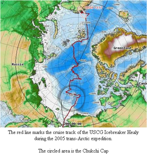
The Chukchi Cap is a large undersea ridge in the Arctic Ocean.[1][2] The cap is normally ice-covered, year-round. The United States Coast Guard Cutter Healy has been sent on multiple missions to map the poorly explored ridge.
The cap lies roughly about 800 kilometres north of the Point Barrow, Alaska.[1][2] The area is notable because it is believed to be rich in natural resources, and it is a disputed water.
References
- ↑ 1.0 1.1 National Oceanic & Atmospheric Administration. United States Explores the Seabed of the Arctic Ocean: to bolster its Claims to the North's Strategic Resources. Canadian American Strategic Review. Retrieved on 2007-09-18.
- ↑ 2.0 2.1 Marie Darling, Donald Perovich. CRREL scientists complete Arctic voyage of discovery. United States Army Corps of Engineers. Retrieved on 2007-09-18.
