Hurricane Ike: Difference between revisions
imported>David E. Volk (Path at landfall) |
mNo edit summary |
||
| (8 intermediate revisions by 5 users not shown) | |||
| Line 1: | Line 1: | ||
{{subpages}} | {{PropDel}}<br><br>{{subpages}} | ||
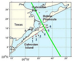
{{Image|Ike LocationsMap web.jpg|right|250px|{{credit}}Hurricane Ike's path during landfall.}} | |||
'''Hurricane Ike''' made landfall on [[Galveston]] Island, Texas at approximately 2:00 AM on September 13th, causing wide-spread damage in the Houston, Texas area. Although it was only a | '''Hurricane Ike''' made landfall on [[Galveston]] Island, Texas at approximately 2:00 AM on September 13th, 2008, causing wide-spread damage in the Houston, Texas area. Although it was only a category 2 storm at landfall, it was a very large storm, and the third costliest in U.S. history. About 2 million people lost electricity in the Houston area, and massive power outages occurred as far inland as Tennessee and Ohio. Many Texas communities in the [[Galveston Bay]] area, including Galveston, Jamaica Beach, Crystal Beach, Surfside, Gilchrist, Winnie, and others suffered severe damage due to both wind damage and storm surge. | ||
[[ | A formal [[After-Action Report]] was published in March 2009, reviewing [[emergency management]]. <ref name=AAR>{{citation | ||
| url = http://www.newsrouter.com/NewsRouter_Uploads/67/HarrisCounty_HurricaneIke_AAR_Final_03_30_2009.pdf | |||
| title = Hurricane Ike After Action Report | |||
| date = March 2009 | |||
| author = Beck Disaster Recovery, Inc. on behalf of Harris County Office of Homeland Security and Emergency Management | |||
| publisher = Harris County, Texas}}</ref> | |||
==What went well== | |||
Staff were highly motivated, elected officials cooperated well with staff, county departments recognized the role of the emergency management office and the [[Citizens Corps]] was effective. Agencies at Federal, regional and local levels cooperated very well on [[HazMat]] response in a large port and industrial area; this is Emergency Support Function 10 in the [[National Incident Management System]] (NIMS]] <ref>AAR, p. 9-12</ref> | |||
==County areas for improvement== | |||
===Planning=== | |||
===Joint Information Center=== | |||
===Public outreach=== | |||
===Finance and administration=== | |||
[[ | ===Logistics=== | ||
===Operations=== | |||
< | ==Non-county areas for improvement== | ||
==References== | |||
{{reflist}}[[Category:Suggestion Bot Tag]] | |||
== | |||
=== | |||
[[ | |||
Latest revision as of 06:01, 30 August 2024
| This article may be deleted soon. | ||
|---|---|---|
Hurricane Ike made landfall on Galveston Island, Texas at approximately 2:00 AM on September 13th, 2008, causing wide-spread damage in the Houston, Texas area. Although it was only a category 2 storm at landfall, it was a very large storm, and the third costliest in U.S. history. About 2 million people lost electricity in the Houston area, and massive power outages occurred as far inland as Tennessee and Ohio. Many Texas communities in the Galveston Bay area, including Galveston, Jamaica Beach, Crystal Beach, Surfside, Gilchrist, Winnie, and others suffered severe damage due to both wind damage and storm surge. A formal After-Action Report was published in March 2009, reviewing emergency management. [1] What went wellStaff were highly motivated, elected officials cooperated well with staff, county departments recognized the role of the emergency management office and the Citizens Corps was effective. Agencies at Federal, regional and local levels cooperated very well on HazMat response in a large port and industrial area; this is Emergency Support Function 10 in the National Incident Management System (NIMS]] [2] County areas for improvementPlanningJoint Information CenterPublic outreachFinance and administrationLogisticsOperationsNon-county areas for improvementReferences
|
||
