Dark Peak: Difference between revisions
imported>Martin Wyatt (New article generated using Special:MetadataForm) |
mNo edit summary |
||
| (46 intermediate revisions by 5 users not shown) | |||
| Line 1: | Line 1: | ||
{{subpages}} | {{subpages}} | ||
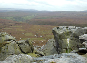
The '''Dark Peak''' is the higher northern part of [[England]]'s [[Peak District]], at the southern end of the [[Pennines]], on the boundaries between the East Midlands and the North of England. It gets its name from the shales and sandstones, predominantly dark, which underlie the [[moorland|moors]] and here and there rise above the surface in dramatic crags. By contrast the White Peak is a [[limestone]] plateau. Another definition of the Dark Peak also includes the lower moors running further south along the east of the Derwent valley.<ref>Barnatt, J. ''Reading the Peak District Landscape''. Historic England. 2019</ref> {{Image|Grinah stones (by bleaklow).jpg|right|350px|Grinah Stones, east of Bleaklow}} | |||
== Geology == | |||
The character of the Dark Peak is formed by its height above the surrounding areas and its geology. The main rocks are sandstones and millstone grit, interpreted as the deposits from a river coming down from a mountain range that once existed in the area of the present Scottish Highlands. There are occasional thin seams of [[peat]] fossilised into coal, worth mining only on the eastern fringes. | |||
The last [[ice age]] seems to have had little effect on the area, apart from a general levelling of the summits and some deposits of boulder clay. | |||
{{Image|Alport castles(3).jpg|right|250px|Alport Castles}}There is a spectacular landslip in the valley of the River Alport, a river which now meanders gently along but was probably larger and more erosive after the last ice age. This has produced the "Alport Castles", which have fallen away from the eastern escarpment, and weathered into fantastic shapes.<ref>Ford, T D. ''Rocks and Scenery of the Peak District Landscape''. Landmark Publishing. 2006</ref> | |||
== Landscape == | |||
In the 1720s, [[Daniel Defoe]], fresh from admiring the splendours of Chatsworth house and estate, wrote: | |||
<blockquote>There is indeed an extended angle of this county, which runs a great way north west by Chappel in the Frith, and which they call High Peak. This, perhaps, is the most desolate, wild, and abandoned country in all England; The mountains of the Peak, of which I have been speaking, seem to be but the beginning of wonders to this part of the country, and but the beginning of mountains, or, if you will, the lower rungs of a ladder. The tops of these hills seem to be as much above the clouds, as the clouds are above the ordinary range of hills.<ref>Defoe, D. ''A Tour through England and Wales''. 2nd volume published 1725, republished 1928 by J M Dent</ref></blockquote> | |||
The exaggeration serves to mark the impact it made. (Defoe, incidentally, got his direction wrong. The area he was writing about is to the north-east, not the north-west, of Chapel en le Frith.) | |||
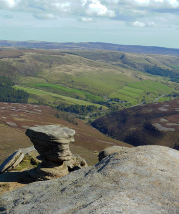
The heart of the area is high moorland, cut by river valleys. {{Image|Fairbrook naze (2.5).jpg|right|350px|Ashop valley from Fairbrook Naze, an outpost of the Kinder plateau, Derwent Edge on the horizon}}The highest point is Kinder Scout, 636 metres, but its so-called summit is actually an almost flat peat-bog lying above steep slopes. Across the head of the Ashop valley to the north is Bleaklow, (aptly named), the next highest point. The moors gradually fall away to the north. To the south of Kinder Scout is a sharp descent into Edale, which may be seen as the boundary with the White Peak. The escarpment from the Kinder plateau into the Ashop valley on its north side is also a sudden descent, and both escarpments have picturesque rock outcrops. Around the head of the Derwent valley, which runs north-south on the east are some of the highest and most striking hills and outcrops, including Horse Stone Naze, the Grinah Stones and the Crow Stones. The stone "Edges" rising above excarpments are among the most striking features of the area. | |||
There is no settlement of more than a few buildings in the central area, but there is a scattering of farms. | |||
==History== | |||
=== Archaeology and early history === | |||
The few finds that have been made from the [[Stone Age|Stone]] and early [[Bronze Age]]s suggest that the area was not settled during those periods, though it was used for hunting. It seems likely that the hunters burnt areas of woodland, in order to assist their hunting and also to attract animals to the new growth in those areas.<ref>Anderson, P & Shimwell, D. '' Wild Flowers and other Plants of the Peak District: An ecological study''. Moorland Publishing. 1981. (Unusual in that over half its length is devoted to the Dark Peak.)</ref> Later settlement has always been sparse. There were Iron Age forts on the edges of the area, at Mam Tor and Carl Wark. | |||
The Romans built a fort (Navio) at Brough in the Hope Valley, immediately to the south. There may have been a Roman road over the Snake Pass, but its route and even its existence are contested.<ref>Barnatt</ref> | |||
Most of the names in the Dark Peak are of [[Anglo-Saxon]] (primarily Anglian) origin. Place name evidence suggests that although there was some [[Scandinavia]]n settlement in the area, it was comparatively slight.<ref>Cameron, K. ''The Place Names of Derbyshire''. Part One. Introduction. Cambridge University Press. 1959</ref> | |||
Many of the farms in the valleys may well be of ancient origin. The names of several of them go back to the 13th century. There are villages on the edges of the central area, one of them a deserted medieval village at Padley.<ref>Hart, C R. ''The North Derbyshire Archaeological Survey: to A D 1500''. sheffield City Museums. 1981</ref> | |||
===Economic activity=== | |||
The industrial activity of the past was mainly associated with extracting minerals and peat from the ground and processing them. Crags, loose rocks and quarries provided millstones, other grinding and dressing stones, and building materials. The millstones were shaped on site, and many complete or partly formed ones are lying around below some Edges. Stone and peat were often brought down by sleds on well-worn routes. | |||
A medieval bole (hearth) for smelting lead may have been situated in Linch Clough, near the upper end of the present Howden reservoir, where the channeling of the wind provided a good draught. Coal was mined on the eastern moors at the end of the 18th and beginning of the 19th century.<ref>Barnatt</ref> | |||
The principal economic activity of the past, livestock farming, has more recently been joined by tourism/recreation, and the [[reservoirs]]. | |||
===Later history and Kinder Scout trespass=== | |||
By the later years of the 19th century, much of the area, in the hands of major landowners such as the Dukes of Rutland and Devonshire, was being preserved for grouse shooting. | |||
In the spring of 1932 some members of the (Communist-backed) British Workers Sports Federation were peremptorily turned off Bleaklow by gamekeepers. Indignantly, the Federation advertised a mass trespass on Kinder Scout for 24 April. Evading the Derbyshire police, probably about 400 walkers came up the western slopes of Kinder Scout, where they were confronted by the Duke of Devonshire's gamekeepers wielding sticks. The walkers overwhelmed the gamekeepers and passed on to the top, where they were met by a smaller group from [[Sheffield]], who had come up from Edale. In the absence of a criminal offence of trespass, five of the walkers, including the organiser Benny (Bernard) Rothman, were charged with public order offences, and were found guilty at Derby Assizes by a jury composed mostly of landowners and military men presided over by an anti-semitic judge, who handed down sentences of between two and six months. | |||
The significance of the trespass is contentious. It was not welcomed by ramblers' organisations, which preferred more orthodox campaigning methods, but both the trespass and the trial gained publicity for the cause of walker access to open ground.<ref>Oxford Dictionary of National Biography, under Rothman, Bernard (Benny); and Hayfield Kinder Trespass Group [http://www.kindertrespass.org.uk]</ref> | |||
The [[National Trust]] has acquired considerable areas of moorland since the early 20th century and undertakes conservation work in those areas.[https://www.nationaltrust.org.uk/kinder-edale-and-the-high-peak] | |||
== Vegetation and fauna == | |||
Much of the moorland plateau is now blanket peat bog, in which most plant nutrients have been leached away, and those plants which once covered the area are now replaced by ones, such as cottongrass, sedge and mosses, which are adapted to wet and nutrient-poor conditions.{{Image|Cotton grass.JPG|right|220px|Cottongrass on peat bank (Bleaklow)}} Heather, bilberry and crowberry, which also require less from the soil are prevalent where it is less wet. The mix of vegetation is less rich than in comparable areas, and this has been attributed to human activity, particularly air pollution. The peat itself has been steadily eroded and not replaced because the sphagnum moss which composes it could no longer thrive; but the national park introduced a programme of replacing it in 2016. | |||
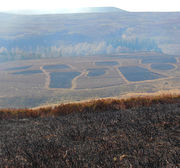
At lower levels there are mixes of heather, grasses and bracken, with other plants among them. Where the moors are managed for grouse-shooting, heather is burnt or otherwise cut back in small areas, in order to ensure enough heather at different stages of growth to support the grouse. This produces an odd patchwork effect on many hillsides. {{Image|Recently burnt heather.jpg|right|180px|Patches of recently burnt heather}} Use of the moorland for sheep grazing, on the other hand, has the effect of encouraging grasses. The plant mix where there are grasses, heather and bracken, is richer than on the tops. At the lowest levels, many areas are kept as pastures, and these have the plants, mostly low-lying, associated with acidic grassland. | |||
The Dark Peak, like much of the rest of England has lost most of its woodland over the last millennium, but woodland cover is below the national average. Monoculture of conifers has not occurred to the same extent as in other upland areas. Mixed woodland and scrub occur in valleys protected from livestock, and attempts are being made to reintroduce trees on some upper slopes.<ref>Anderson & Shimwell</ref> | |||
Among the fauna, the main species of interest to the non-specialist is the mountain hare, brown in summer, white in winter, here at the extreme southern limit of its range. | |||
== Roads, tracks, paths == | |||
Two major roads run roughly east-west through the area, connecting the [[Greater Manchester|Manchester]] and Sheffield conurbations. The northern route, the Woodhead pass, is signposted to direct more traffic onto it, and avoids the more dramatic countryside. The southern one, the Snake pass, goes up the Ashop valley and descends steeply into Glossop. It is subject to landslip, and at the moment (June 2022) is barred to heavy lorries. | |||
Two long distance footpaths cross the area: the Pennine Way, running north from Edale to the [[Scottish Borders]], and the Trans-Pennine Trail (which is also a cycle route) running east-west, coast to coast. Parts of the Pennine Trail are paved because of the heavy usage, but some parts are currently (2021) in poor condition. There are numerous footpaths and bridleways, and the great majority of the land is open access to walkers. | |||
There are various farm tracks and other tracks, often popular with mountain bikers (see under Recreational use below); also a few sledge routes once used for bringing stone down from the crags (see above under Archaeology and early history/Industry). | |||
== Recreational use == | |||
The [[Peak District]] National Park as a whole has more visitors than any other in England, and parts of the Dark Peak are heavily used. | |||
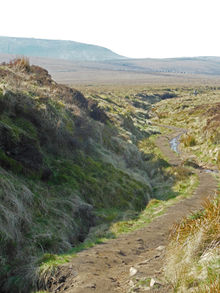
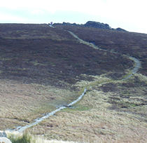
'''Walking''' The Dark Peak offers walks of all standards from gentle strolls along the banks of reservoirs to strenuous long-distance hikes across difficult terrain. A well used route up and {{Image|Pennine way.JPG|right|220px|Pennine Way looking south with A57 and Kinder Scout in background.}} along Derwent Edge involves a climb and descent of about 200 metres. Paths such as these are fortified and repaired by the National Park Authority or its partners to prevent erosion. Certain routes are very well used, but others not, though it is rare never to meet other walkers. | |||
'''Running''' on the steep slopes is practised for fitness, or as orienteering, or for enjoyment in itself. | |||
'''Biking''' The Dark Peak offers mountain bikers the steep slopes and rock-strewn tracks which provide them with a struggle upwards and a perilous fast descent. The use of the area for moto-cross seems to have been mostly stamped out. There are also gentler cycle routes, which are well used, especially the one around the Derwent reservoirs. | |||
'''Riding''' Although there are many bridleways in the area, these are used more by cyclists than by horse-riders. | |||
'''Climbing''' Rock-climbing and bouldering are mostly confined to the rock Edges on the periphery of the area, these being easily accessible with equipment. The rocky heights in the central part are less used. | |||
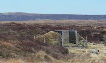
'''Grouse shooting''' There are extensive grouse moors within the area, with shooting butts served by tracks for four-wheel drive vehicles. The vegetation is often managed to favour grouse, giving a curious patchwork effect. | |||
== Reservoirs == | |||
{{Image|Ladybower dam.jpg|right|280px|Ladybower dam and part of reservoir, from Bamford Edge}} | |||
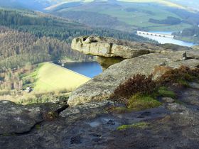
Nearby [[conurbation]]s have taken advantage of the high rainfall in the Dark Peak to supply their need for water. From the 18th century, small reservoirs have been built around the edges of the area. In the mid-19th century a string of reservoirs was constructed along the course of the River Etherow in the Longdendale valley, starting with Rhodeswood (1848—55), Torside (1848—64), and Woodhead (1848—77), with Valehouse (1865—69) and Bottoms (1865—77) added to later because of the need to keep a flow of water in the river downstream. In the 20th century three large reservoirs were built on the Derwent. The first two, Howden and Derwent were built 1901—19, and a new village to house the workforce was built on the site of Birchinlee Farm and named after it. It was demolished when the work was completed. In the 1920s a conduit or leat was constructed to take water from the upper reaches of the Ashop, running parallel to it and then crossing it, to flow into the Derwent reservoir.<ref>Robinson, Brian. ''Walls Across the Valley: Building of the Howden and Derwent Dams''. Scarthin Books.1993</ref> The third reservoir was Ladybower, built 1932—44. The banks of these reservoirs are used for recreational purposes.<ref>Barnatt</ref> | |||
== Aircraft wrecks == | |||
Many aircraft have crashed onto these heights, enough for an ordinary walker to come across several without looking for them; but there are guidebooks to to tell those interested where to find them and to give their history. | |||
== Local authorities == | |||
The Peak District National Park Authority is the planning authority for the area and has other powers. Its members are appointed by the 11 local authorities which have land in the national park, and by the Secretary of State to fill various categories, including representation of parish councils. The authorities which have land within the Dark Peak are Derbyshire County Council and High Peak Borough Council and the unitary authorities for Barnsley, Kirklees, Oldham and Sheffield. | |||
== References == | |||
<references/> | |||
{{Image|Bleaklow hill.JPG|left|240px|Bleaklow Hill and upper Alport Valley.}}{{Image|Grouse butt 9.jpg|center|210px|Grouse butt near Alport Castles.}}{{Image|Back tor to lost lad.jpg|right|210px|Paved path on a popular walking route (Back Tor)}}[[Category:Suggestion Bot Tag]] | |||
Latest revision as of 16:00, 4 August 2024
The Dark Peak is the higher northern part of England's Peak District, at the southern end of the Pennines, on the boundaries between the East Midlands and the North of England. It gets its name from the shales and sandstones, predominantly dark, which underlie the moors and here and there rise above the surface in dramatic crags. By contrast the White Peak is a limestone plateau. Another definition of the Dark Peak also includes the lower moors running further south along the east of the Derwent valley.[1]
Geology
The character of the Dark Peak is formed by its height above the surrounding areas and its geology. The main rocks are sandstones and millstone grit, interpreted as the deposits from a river coming down from a mountain range that once existed in the area of the present Scottish Highlands. There are occasional thin seams of peat fossilised into coal, worth mining only on the eastern fringes.
The last ice age seems to have had little effect on the area, apart from a general levelling of the summits and some deposits of boulder clay.
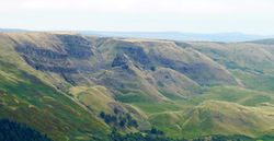
There is a spectacular landslip in the valley of the River Alport, a river which now meanders gently along but was probably larger and more erosive after the last ice age. This has produced the "Alport Castles", which have fallen away from the eastern escarpment, and weathered into fantastic shapes.[2]
Landscape
In the 1720s, Daniel Defoe, fresh from admiring the splendours of Chatsworth house and estate, wrote:
There is indeed an extended angle of this county, which runs a great way north west by Chappel in the Frith, and which they call High Peak. This, perhaps, is the most desolate, wild, and abandoned country in all England; The mountains of the Peak, of which I have been speaking, seem to be but the beginning of wonders to this part of the country, and but the beginning of mountains, or, if you will, the lower rungs of a ladder. The tops of these hills seem to be as much above the clouds, as the clouds are above the ordinary range of hills.[3]
The exaggeration serves to mark the impact it made. (Defoe, incidentally, got his direction wrong. The area he was writing about is to the north-east, not the north-west, of Chapel en le Frith.)
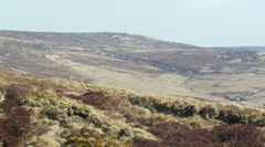
The heart of the area is high moorland, cut by river valleys.
The highest point is Kinder Scout, 636 metres, but its so-called summit is actually an almost flat peat-bog lying above steep slopes. Across the head of the Ashop valley to the north is Bleaklow, (aptly named), the next highest point. The moors gradually fall away to the north. To the south of Kinder Scout is a sharp descent into Edale, which may be seen as the boundary with the White Peak. The escarpment from the Kinder plateau into the Ashop valley on its north side is also a sudden descent, and both escarpments have picturesque rock outcrops. Around the head of the Derwent valley, which runs north-south on the east are some of the highest and most striking hills and outcrops, including Horse Stone Naze, the Grinah Stones and the Crow Stones. The stone "Edges" rising above excarpments are among the most striking features of the area.
There is no settlement of more than a few buildings in the central area, but there is a scattering of farms.
History
Archaeology and early history
The few finds that have been made from the Stone and early Bronze Ages suggest that the area was not settled during those periods, though it was used for hunting. It seems likely that the hunters burnt areas of woodland, in order to assist their hunting and also to attract animals to the new growth in those areas.[4] Later settlement has always been sparse. There were Iron Age forts on the edges of the area, at Mam Tor and Carl Wark.
The Romans built a fort (Navio) at Brough in the Hope Valley, immediately to the south. There may have been a Roman road over the Snake Pass, but its route and even its existence are contested.[5]
Most of the names in the Dark Peak are of Anglo-Saxon (primarily Anglian) origin. Place name evidence suggests that although there was some Scandinavian settlement in the area, it was comparatively slight.[6]
Many of the farms in the valleys may well be of ancient origin. The names of several of them go back to the 13th century. There are villages on the edges of the central area, one of them a deserted medieval village at Padley.[7]
Economic activity
The industrial activity of the past was mainly associated with extracting minerals and peat from the ground and processing them. Crags, loose rocks and quarries provided millstones, other grinding and dressing stones, and building materials. The millstones were shaped on site, and many complete or partly formed ones are lying around below some Edges. Stone and peat were often brought down by sleds on well-worn routes.
A medieval bole (hearth) for smelting lead may have been situated in Linch Clough, near the upper end of the present Howden reservoir, where the channeling of the wind provided a good draught. Coal was mined on the eastern moors at the end of the 18th and beginning of the 19th century.[8]
The principal economic activity of the past, livestock farming, has more recently been joined by tourism/recreation, and the reservoirs.
Later history and Kinder Scout trespass
By the later years of the 19th century, much of the area, in the hands of major landowners such as the Dukes of Rutland and Devonshire, was being preserved for grouse shooting.
In the spring of 1932 some members of the (Communist-backed) British Workers Sports Federation were peremptorily turned off Bleaklow by gamekeepers. Indignantly, the Federation advertised a mass trespass on Kinder Scout for 24 April. Evading the Derbyshire police, probably about 400 walkers came up the western slopes of Kinder Scout, where they were confronted by the Duke of Devonshire's gamekeepers wielding sticks. The walkers overwhelmed the gamekeepers and passed on to the top, where they were met by a smaller group from Sheffield, who had come up from Edale. In the absence of a criminal offence of trespass, five of the walkers, including the organiser Benny (Bernard) Rothman, were charged with public order offences, and were found guilty at Derby Assizes by a jury composed mostly of landowners and military men presided over by an anti-semitic judge, who handed down sentences of between two and six months.
The significance of the trespass is contentious. It was not welcomed by ramblers' organisations, which preferred more orthodox campaigning methods, but both the trespass and the trial gained publicity for the cause of walker access to open ground.[9]
The National Trust has acquired considerable areas of moorland since the early 20th century and undertakes conservation work in those areas.[2]
Vegetation and fauna
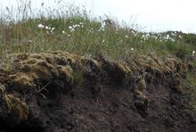
Much of the moorland plateau is now blanket peat bog, in which most plant nutrients have been leached away, and those plants which once covered the area are now replaced by ones, such as cottongrass, sedge and mosses, which are adapted to wet and nutrient-poor conditions.
Heather, bilberry and crowberry, which also require less from the soil are prevalent where it is less wet. The mix of vegetation is less rich than in comparable areas, and this has been attributed to human activity, particularly air pollution. The peat itself has been steadily eroded and not replaced because the sphagnum moss which composes it could no longer thrive; but the national park introduced a programme of replacing it in 2016. At lower levels there are mixes of heather, grasses and bracken, with other plants among them. Where the moors are managed for grouse-shooting, heather is burnt or otherwise cut back in small areas, in order to ensure enough heather at different stages of growth to support the grouse. This produces an odd patchwork effect on many hillsides.
Use of the moorland for sheep grazing, on the other hand, has the effect of encouraging grasses. The plant mix where there are grasses, heather and bracken, is richer than on the tops. At the lowest levels, many areas are kept as pastures, and these have the plants, mostly low-lying, associated with acidic grassland.
The Dark Peak, like much of the rest of England has lost most of its woodland over the last millennium, but woodland cover is below the national average. Monoculture of conifers has not occurred to the same extent as in other upland areas. Mixed woodland and scrub occur in valleys protected from livestock, and attempts are being made to reintroduce trees on some upper slopes.[10]
Among the fauna, the main species of interest to the non-specialist is the mountain hare, brown in summer, white in winter, here at the extreme southern limit of its range.
Roads, tracks, paths
Two major roads run roughly east-west through the area, connecting the Manchester and Sheffield conurbations. The northern route, the Woodhead pass, is signposted to direct more traffic onto it, and avoids the more dramatic countryside. The southern one, the Snake pass, goes up the Ashop valley and descends steeply into Glossop. It is subject to landslip, and at the moment (June 2022) is barred to heavy lorries.
Two long distance footpaths cross the area: the Pennine Way, running north from Edale to the Scottish Borders, and the Trans-Pennine Trail (which is also a cycle route) running east-west, coast to coast. Parts of the Pennine Trail are paved because of the heavy usage, but some parts are currently (2021) in poor condition. There are numerous footpaths and bridleways, and the great majority of the land is open access to walkers.
There are various farm tracks and other tracks, often popular with mountain bikers (see under Recreational use below); also a few sledge routes once used for bringing stone down from the crags (see above under Archaeology and early history/Industry).
Recreational use
The Peak District National Park as a whole has more visitors than any other in England, and parts of the Dark Peak are heavily used.
Walking The Dark Peak offers walks of all standards from gentle strolls along the banks of reservoirs to strenuous long-distance hikes across difficult terrain. A well used route up and
along Derwent Edge involves a climb and descent of about 200 metres. Paths such as these are fortified and repaired by the National Park Authority or its partners to prevent erosion. Certain routes are very well used, but others not, though it is rare never to meet other walkers.
Running on the steep slopes is practised for fitness, or as orienteering, or for enjoyment in itself.
Biking The Dark Peak offers mountain bikers the steep slopes and rock-strewn tracks which provide them with a struggle upwards and a perilous fast descent. The use of the area for moto-cross seems to have been mostly stamped out. There are also gentler cycle routes, which are well used, especially the one around the Derwent reservoirs.
Riding Although there are many bridleways in the area, these are used more by cyclists than by horse-riders.
Climbing Rock-climbing and bouldering are mostly confined to the rock Edges on the periphery of the area, these being easily accessible with equipment. The rocky heights in the central part are less used.
Grouse shooting There are extensive grouse moors within the area, with shooting butts served by tracks for four-wheel drive vehicles. The vegetation is often managed to favour grouse, giving a curious patchwork effect.
Reservoirs
Nearby conurbations have taken advantage of the high rainfall in the Dark Peak to supply their need for water. From the 18th century, small reservoirs have been built around the edges of the area. In the mid-19th century a string of reservoirs was constructed along the course of the River Etherow in the Longdendale valley, starting with Rhodeswood (1848—55), Torside (1848—64), and Woodhead (1848—77), with Valehouse (1865—69) and Bottoms (1865—77) added to later because of the need to keep a flow of water in the river downstream. In the 20th century three large reservoirs were built on the Derwent. The first two, Howden and Derwent were built 1901—19, and a new village to house the workforce was built on the site of Birchinlee Farm and named after it. It was demolished when the work was completed. In the 1920s a conduit or leat was constructed to take water from the upper reaches of the Ashop, running parallel to it and then crossing it, to flow into the Derwent reservoir.[11] The third reservoir was Ladybower, built 1932—44. The banks of these reservoirs are used for recreational purposes.[12]
Aircraft wrecks
Many aircraft have crashed onto these heights, enough for an ordinary walker to come across several without looking for them; but there are guidebooks to to tell those interested where to find them and to give their history.
Local authorities
The Peak District National Park Authority is the planning authority for the area and has other powers. Its members are appointed by the 11 local authorities which have land in the national park, and by the Secretary of State to fill various categories, including representation of parish councils. The authorities which have land within the Dark Peak are Derbyshire County Council and High Peak Borough Council and the unitary authorities for Barnsley, Kirklees, Oldham and Sheffield.
References
- ↑ Barnatt, J. Reading the Peak District Landscape. Historic England. 2019
- ↑ Ford, T D. Rocks and Scenery of the Peak District Landscape. Landmark Publishing. 2006
- ↑ Defoe, D. A Tour through England and Wales. 2nd volume published 1725, republished 1928 by J M Dent
- ↑ Anderson, P & Shimwell, D. Wild Flowers and other Plants of the Peak District: An ecological study. Moorland Publishing. 1981. (Unusual in that over half its length is devoted to the Dark Peak.)
- ↑ Barnatt
- ↑ Cameron, K. The Place Names of Derbyshire. Part One. Introduction. Cambridge University Press. 1959
- ↑ Hart, C R. The North Derbyshire Archaeological Survey: to A D 1500. sheffield City Museums. 1981
- ↑ Barnatt
- ↑ Oxford Dictionary of National Biography, under Rothman, Bernard (Benny); and Hayfield Kinder Trespass Group [1]
- ↑ Anderson & Shimwell
- ↑ Robinson, Brian. Walls Across the Valley: Building of the Howden and Derwent Dams. Scarthin Books.1993
- ↑ Barnatt
