Ganges River: Difference between revisions
imported>Pradyumna Singh No edit summary |
imported>Pradyumna Singh (Working table of tributaries) |
||
| Line 64: | Line 64: | ||
====Sequence of tributary confluence==== | ====Sequence of tributary confluence==== | ||
Alaknanda joins Dhauliganga (at Vishnuprayag), Mandakini (at Nandprayag), Pindar (at Karnaprayag), Mandakini (at Rudraprayag) and ultimately Bhagirathi (at Devaprayag) from where onwards, it is known as [[Ganga]]. The Bhagirathi is considered the prime source stream, fed by melting glacial snow and ice from peaks such as Kamet and Nanda Devi. | Alaknanda joins Dhauliganga (at Vishnuprayag), Mandakini (at Nandprayag), Pindar (at Karnaprayag), Mandakini (at Rudraprayag) and ultimately Bhagirathi (at Devaprayag) from where onwards, it is known as [[Ganga]]. The Bhagirathi is considered the prime source stream, fed by melting glacial snow and ice from peaks such as Kamet and Nanda Devi. | ||
{| class="prettytable sortable" | |||
! Name<br /><br /><br /> || Mouth<br />of<br /><br /> || Discharge<br />(MQ)<br />[m³/s]<br /> || Length<br />[km]<br /><br /> || Catchment-<br />area<br />[km²] || Swell<br />[m.]<br /><br /> || Estuary-<br />height<br />[m.] || Confluence-<br />place<br /><br /> | |||
|- | |||
|colspan="8"| '''Headstreams'''<ref name="data1">Singh, Hasnain: [http://www.iahs.info/hsj/430/hysj_43_06_0825.pdf ''Major ion chemistry and weathering control in a high altitude basin: Alaknanda River, Garhwal Himalaya, India''] (PDF; 1,3 MB), 1998</ref><ref>Arun Kumar: [http://www.moef.nic.in/downloads/public-information/CH-7.pdf ''Assessment of Cumulative Impact of Hydropower Projects in Alaknanda and Bhagirathi Basins''] (PDF; 5,6 MB), Chapter 7 Hydrology 30. Mar 2011</ref> | |||
|- | |||
| [[Alaknanda]] | |||
| align="center" | left | |||
| align="right" | 440 | |||
| align="right" | 240 | |||
| align="right" | 12587 | |||
| align="right" | 4350 | |||
| align="right" | 460 | |||
| align="center" | [[Devprayag]] | |||
|- | |||
| [[Bhagirathi]] | |||
| align="center" | right | |||
| align="right" | 260 | |||
| align="right" | 254<ref>qaqa</ref> | |||
| align="right" | 7820 | |||
| align="right" | 4120 | |||
| align="right" | 460 | |||
| align="center" | [[Devprayag]] | |||
|- | |||
|colspan="8"| '''Tributaries'''<ref name="data2">Sharad K. Jain, Pushpendra K. Agarwal, Vijay P. Singh: Hydrology and water resources of India. New York 2007</ref> | |||
|- | |||
| [[Ramganga]] | |||
| align="center" | left | |||
| align="right" | 490 | |||
| align="right" | 596 | |||
| align="right" | 32493 | |||
| align="right" | 3110 | |||
| align="right" | 130 | |||
| align="center" | Ibrahimpur | |||
|- | |||
| [[Yamuna]] | |||
| align="center" | right | |||
| align="right" | 2940 | |||
| align="right" | 1376 | |||
| align="right" | 366223 | |||
| align="right" | 6387 | |||
| align="right" | 74 | |||
| align="center" | Sahon | |||
|- | |||
| [[Ghaghara]] | |||
| align="center" | left | |||
| align="right" | 2980 | |||
| align="right" | 1080 | |||
| align="right" | 127950 | |||
| align="right" | 4800 | |||
| align="right" | 48 | |||
| align="center" | [[Chapra]] | |||
|- | |||
| [[Son (Ganges)|Son]] | |||
| align="center" | right | |||
| align="right" | 900 | |||
| align="right" | 784 | |||
| align="right" | 71259 | |||
| align="right" | 600 | |||
| align="right" | 46 | |||
| align="center" | Dinapur | |||
|- | |||
| [[Gandak]] | |||
| align="center" | left | |||
| align="right" | 1640 | |||
| align="right" | 630 | |||
| align="right" | 46300 | |||
| align="right" | 7620 | |||
| align="right" | 44 | |||
| align="center" | Sonepur | |||
|- | |||
| [[Kosi]] | |||
| align="center" | left | |||
| align="right" | 2160 | |||
| align="right" | 835 | |||
| align="right" | 95156 | |||
| align="right" | 7000 | |||
| align="right" | 34 | |||
| align="center" | Kursela | |||
|- | |||
|} | |||
===Ganga in Indian Religion=== | ===Ganga in Indian Religion=== | ||
Revision as of 12:38, 19 November 2014
| Ganga | |
|---|---|
| A major river of India | |
| General | |
| Country | India |
| States | Uttarakhand, Uttar Pradesh, Bihar, Jharkhand, West Bengal, |
| Cities | Haridwar, Kanpur, Allahabad, Varanasi, Kolkata |
| Source | Gangotri Glacier, Uttarakhand, India, |
| Mouth | Bay of Bengal |
| Length | 2,525 km |
| Left Tributaries | Mahakhali, Karnali, Kosi, Gandak, Ghaghra |
| Right Tributaries | Yamuna, Son, Mahananda |
| Basin | 14,270 cu.m/sec |
| Ganga | |
Article Authors : P.Singh
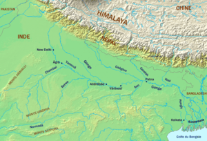
Ganga, official name "Ganga/Ganges"[1], (archaic Ganges) is a major river system in the Indian subcontinent flowing East through North India's Gangetic plains, traversing 2,525 km in the course to discharge into the Bay of Bengal through its vast delta in the Sunderbans and Bangladesh. Several important tributaries add their waters during this journey to make Ganga the 3rd largest river in the world by discharge volume.
The Ganga river basin is India's largest, irrigating the Northern states of Uttarakhand, Uttar Pradesh, Haryana, Rajasthan, Himachal Pradesh, Delhi, Madhya Pradesh, Chhattisgarh, Bihar, Jharkhand, and West Bengal. Important Indian cities on its banks include Kanpur, Patna, Kannauj, Kashi, Allahabad, Varanasi, Kolkata.
Course of the Ganga

Tributaries of the Ganga
Other than the Yamuna river, the major water-rich tributaries of the Ganges flow to the left. Originating mostly in the Himalayas they mitigate the low dissolved oxygen and pollutant concentration of the main stream. However, some of these tributaries also cause the largest flood hazard zone of the Ganges and regular overflowing of its high water banks causing destruction.
Sequence of tributary confluence
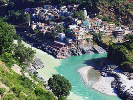
Alaknanda joins Dhauliganga (at Vishnuprayag), Mandakini (at Nandprayag), Pindar (at Karnaprayag), Mandakini (at Rudraprayag) and ultimately Bhagirathi (at Devaprayag) from where onwards, it is known as Ganga. The Bhagirathi is considered the prime source stream, fed by melting glacial snow and ice from peaks such as Kamet and Nanda Devi.
| Name |
Mouth of |
Discharge (MQ) [m³/s] |
Length [km] |
Catchment- area [km²] |
Swell [m.] |
Estuary- height [m.] |
Confluence- place |
|---|---|---|---|---|---|---|---|
| Headstreams[2][3] | |||||||
| Alaknanda | left | 440 | 240 | 12587 | 4350 | 460 | Devprayag |
| Bhagirathi | right | 260 | 254[4] | 7820 | 4120 | 460 | Devprayag |
| Tributaries[5] | |||||||
| Ramganga | left | 490 | 596 | 32493 | 3110 | 130 | Ibrahimpur |
| Yamuna | right | 2940 | 1376 | 366223 | 6387 | 74 | Sahon |
| Ghaghara | left | 2980 | 1080 | 127950 | 4800 | 48 | Chapra |
| Son | right | 900 | 784 | 71259 | 600 | 46 | Dinapur |
| Gandak | left | 1640 | 630 | 46300 | 7620 | 44 | Sonepur |
| Kosi | left | 2160 | 835 | 95156 | 7000 | 34 | Kursela |
Ganga in Indian Religion
Ganga in Hinduism
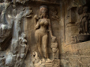
The river Ganga is generally regarded, since ancient times, amongst the world's most important and holy rivers. It is held sacred by Indians, especially Hindus, and is also worshiped in its anthropomorphic form as the Goddess Ganga, emerging, from Bhagirathi her source, at Gangotri Glacier (in the Central Himalayan state of Uttarakhand) at Gaumukh (elevation 3,892 m). Ganga is embodied at Devprayag when the rampant Alaknanda joins swirling Bhagirathi. Numerous other streams join Himalayan Ganga, among these Mandakini, Dhauliganga, Bhilangana and Pindar are significant.
Ganges in West Bengal
The sanctity of Ganga of Ganga in Bengal predates the arrival of Indo-Aryans. After their arrival and association of Ganga river with Aryan purity, important places of pilgrimage came up at Nawadeep, Triveni, Katwa, Ganga Sagar and Kalighat (near Kolkatta).
Ganga in Islam
Leading Islamic clerics in India have agreed that it is the duty of both Hindus and Muslim to protect and save Ganga, a national river, as both communities live on its banks and earn livelihood from it.[6]
Ganga in Bangladesh
The portions of the eastern sub-delta of the Ganga is known as Padma and had no religious significance or historical places of pilgrimage for Indians unlike in West Bengal along the banks of the Bhagirathi-Hooghly section known a Adi Ganga. The eastern deltaic portions mainly in Bangladesh were always cut off symbolically from Indo-Aryan culture and mythology.[7]
References
- ↑ Ganga/Ganges bilateral water sharing treaty, 1996
- ↑ Singh, Hasnain: Major ion chemistry and weathering control in a high altitude basin: Alaknanda River, Garhwal Himalaya, India (PDF; 1,3 MB), 1998
- ↑ Arun Kumar: Assessment of Cumulative Impact of Hydropower Projects in Alaknanda and Bhagirathi Basins (PDF; 5,6 MB), Chapter 7 Hydrology 30. Mar 2011
- ↑ qaqa
- ↑ Sharad K. Jain, Pushpendra K. Agarwal, Vijay P. Singh: Hydrology and water resources of India. New York 2007
- ↑ Muslim clerics support save Ganga campaign
- ↑ Rise of Islam and Bengal Frontier


