Owens Lake: Difference between revisions
Pat Palmer (talk | contribs) m (Text replacement - "Los Angeles" to "Los Angeles") |
mNo edit summary |
||
| Line 46: | Line 46: | ||
==References== | ==References== | ||
{{reflist|2}} | {{reflist|2}}[[Category:Suggestion Bot Tag]] | ||
Latest revision as of 11:00, 30 September 2024
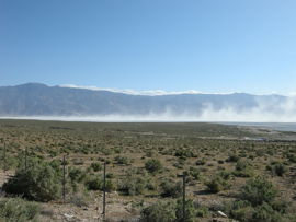
Owens Lake in Inyo County, California, USA, was once almost as large in surface area as the better-known Lake Tahoe between California and Nevada. Today it is infamous for the large amount of particulate matter that it generates, leading to air pollution. When it was a desert lake, it supported charcoal kilns, steamers, a flyway for migratory birds, and local agriculture. For many years, beginning in 1913, Owens Lake was mostly a dry lake bed with small patches of water. This was a result of the lower Owens River being diverted into an aqueduct serving as a water supply for Los Angeles; this also led to one of the largest man-made sources of air pollution by dust (particulate matter). Recently, however, much of the dry bed has been re-ponded and a substantial portion of the original lake area is once again under water.
History
The Owens Valley, where Owens Lake is located, is part of the westernmost graben[1] of the Basin and Range province, lying between two almost vertical faults. To the west is the Sierra Nevada range while the Inyo-White mountains are located to the east. Formation of the valley began approximately 3 million years ago during the Pliocene period.
The area is seismically active and an estimated 8.0 earthquake in 1872 inLone Pine, California, killed 23 people. Most of the buildings in Lone Pine were also destroyed. Volcanic activity is also reported in the area as the Owens Valley is part of the Long Valley Caldera. Volcanic eruptions of the Inyo Chain were reported as early as 600 years ago.[2]
John C. Fremont explored the area and named the lake after his associate Richard Owens. Native Americans who lived in the area included the Paiute, Mojave and Shoshone tribes. By the 1860s settlers moved into the Owens Lake area. Silver miners moved to the area when silver was discovered at Cerro Gordo located in mountains east of Owens Lake. Cerro Gordo is considered a ghost town and is open to tourists.
Farming soon followed after the early settlers arrived in the area. Wheat, potatoes, apples, corn andgrapes were being grown in the area in 1910. 43,000 sheep were also raised by local farmers.[3] Logging and a sawmill was built by Colonel Sherman Stevens in the 1870s. Lumber was used to build Stevens Wharf at Owens Lake. The wharf was built on the west side of the lake where the lumber was loaded onto steamers. The lumber was then ferried across the lake where it was unloaded onto a dock, from which point it was taken to the local mines on freight wagons.
Stevens also built a pair of adobe ovens that produced charcoal for the Cerro Gordo mines. lThe steamers Molly Stevens and Bessie Brady were used to carry ore from the mines to waiting freight wagons. The ore was shipped down to Los Angeles.[3][4]
Water for Los Angeles
The City of Los Angeles bought up the water rights between 1905 and 1907, and proposed and appropriated congressional funding for the Los Angeles aqueduct. The aqueduct was built between 1910 and 1913, and, when it was completed on November 5, 1913, 30,000 Los Angeles residents gathered in the San Fernando Valley at the “Cascades” to celebrate its opening. Bottles of Owens Valley water were distributed, speeches were made, and the aqueduct gates were opened. Water trickled forth.[5]
By 1970 a second aqueduct was completed after theU.S. Supreme Court allocated more Colorado River rights to Arizona leaving Los Angeles searching for more water sources. The newly built aqueduct ran from the Haiwee, California reservoir just south of the Owens Lake dry river bed. After the construction of the second aqueduct, 70 percent of Los Angeles' water came from the Owens Valley area.[6]
Air pollution
In the past, the Owens Lake dry bed area was characterized as being the largest single source of PM10 (particulate matter less than 10 microns in size) in the United States of America by the Great Basin Unified Air Pollution Control District (GBUAPCD)[7][8]. That characterization was based on an approximate, unscientific estimate made in about 1986 that the annual PM10 emissions were 300,000 tons.[9] Subsequently, the GBUAPCD monitored and scientifically tested the PM10 emissions over a long period, including daily measurements from the period of July 2000 to 2001, and determined the annual PM10 emissions were only 79,000 tons for that year-long test period.[10] That is equivalent to an average of 217 tons per day. During that test period, a single peak daily value of 7,200 tons was encountered.
During the 1980s and the early 1990s, the U.S. Environmental Protection Agency (U.S. EPA) had designated the Owens Lake area as having not attained the National Ambient Air Quality Standards (NAAQS) for PM10. The wind-blown sand and PM10 air pollution affected approximately 40,000 residents living near Owens Lake. Regionally the blowing sand and dust also affected U.S. Forest Service employees and the United States Navy's air weapons station located at nearby China Lake.[11] During those same years, nearby residents in Keeler, California reportedly were exposed to 25 unhealthful days a year while residents in the town of Ridgecrest, California experienced 10 unhealthful days per year due to the PM10 air pollution. An emergency physician at the Ridgecrest Community Hospital was reported as saying "When we see the white cloud headed down through the pass, the ER and doctors' offices fill up with people who suddenly got worse. It's a pretty straightforward cause and effect.” [12]
In the late 1990s, after many years of litigation and negotiations that included the city of Los Angeles through its Department of Water and Power (LADWP), the Great Basin Unified Air Pollution Control District (GBUAPCD), the U.S. EPA, the U.S. Navy, the California State Lands Commission and other interested parties, the California Air Resources Board (CARB) submitted a State Implementation Plan (SIP)[13] to the U.S. EPA as required by the United States' Clean Air Act (CAAA).[11] In accordance with that SIP, the LADWP was made responsible for installing and operating dust control measures on Owens Lake so as to attain the ambient air quality standards of the NAAQS. As of December 17, 2010, the air quality of the Owens Valley had not yet attained the NAAQS standards for (PM10)[14] and its non-attainment status is still designated by the EPA as being "Serious".[15]
However, the LADWP had made much progress:[16][17][18][19]
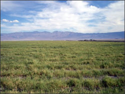
- The Owens Lake dust control project currently stretches across approximately 30 of the lake’s 100 square miles. About 27 square miles are covered with ponded water or are shallow-flooded and about 3.5 square miles have been re-vegetated and covered with native saltgrass (see the adjacent photo). The saltgrass is irrigated by a water drip system.
- About 64 acres (0.1 square miles) has been covered with gravel as a dust control measure.
- An additional 9 square miles of ponding and shallow-flooding were planned to be added by the LADWP some time in 2010.
- The ponding and shallow-flooding have resulted in a substantial increase in wetlands habitat.
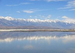
- Owens Lake has once again become a bird sanctuary and a major migratory stop-over site for shorebirds and waterfowl. Each spring and fall, brine flies on the lake support thousands of shorebirds, mainly sandpipers, and thousands of ducks utilize the wetlands habitat. An estimated 63,000 American Avocets stop at the lake during fall and a group of 300 to 400 Snow Geese now winters at Owens Lake.
- The National Audubon Society has now designated the Owens Lake bird sanctuary (see the adjacent photo) as a "Important Bird Area" (IBA).
The LADWP is also scheduled to complete a plan for the long-term habitat management in the entire dust control project area. To that end, the LADWP is cooperating with the GBUAPCD, the California Department of Fish and Game, the Audubon Society and theNature Conservancy in the development of a long-term habitat management plan for the entire Lake Owens project. The plan will examine and consider the dust control project as well as the springs and wetlands around the shoreline of the lake and is intended to help managers and conservation groups preserve the lake's rich wildlife resources.[18]
As noted earlier above, the non-attainment status of the Owens Lake area is still designated as "Serious" by the U.S. EPA.[15] However, as part of a detailed discussion in the United States' Federal Register on June 24, 2010, of a proposed ruling to be made by the U.S. EPA, it is stated that there has been a 90 percent decrease in emissions from the Owens lake area.[20] That same assessment (a 90 percent decrease in emissions) has been made in a recent presentation by the GBUAPCD and the LADWP to the Owens Lake Planning Committee.[21] Therefore, it is probable that the current non-attainment status of "Serious" may be revised in the near future.
References
- ↑ Note: A graben is an elongated depression between geologic faults.
- ↑ Manzanar National Historic Site Geological Resources Management Issues Scoping Summary From National Park Service website. Retrieved on 2011-01-31.
- ↑ 3.0 3.1 Chronological History of Owens Valley Note that the chronology ends in 1954. Retrieved on 2011-01-3.
- ↑ Finding reminders of Owens Lake’s rich history From website of the Lahontan Valley News. Retrieved on 2011-01-31.
- ↑ This Rude Platform is an Altar From website of the Los Angeles Department of Water and Power. Retrieved on 2011-02-01.
- ↑ New Era for Old Foes in Water Wars From website of the Los Angeles Times. Retrieved on 2011-01-31.
- ↑ Survey of Reported Health Effects of Owens Lake Particulate Matter January, 2000. Retrieved from the website of the Great Basin Unified Air Pollution Control District (GBUAPCD) on 2011-01-31.
- ↑ Note: The primary air pollution regulatory agency in the state of California is the California Air Resources Board (CARB). The GBUAPCD is one of the 35 air pollution control districts, which report to CARB and which address air pollution problems at the local level.
- ↑ Personal correspondence in an email from Mr. Ted Schade of the GBUAPCD on February 3, 2011.
- ↑ Quantifying Particulate Matter Emissions from Wind Blown Dust Using Real-time Sand Flux Measurements Duane Ono and Scott Weaver of the Great Basin Unified Air Pollution Control District, and Ken Richmond of MFG, Inc., U.S. EPA Emission Inventory Conference, San Diego, California, April 2003. From website of the U.S. EPA. Retrieved on 2011-01-31.
- ↑ 11.0 11.1 Owens Valley, CA Particulate Matter Plan: History Note that this history from website of the U.S. EPA ends in about 1999. Retrieved on 2011-01-31.
- ↑ Owens (Dry) Lake, California: A Human-Induced Dust Problem Abstracted from: Reheis, M.C., in press, Dust deposition downwind of Owens (Dry) Lake, 1991-1994: Preliminary findings. Retrieved from website of the U.S. Geological Survey on 2011-01-31.
- ↑ Note: An SIP is a detailed plan of how to achieve a healthy ambient air quality as required by the United States' Clean Air Act.
- ↑ Note: The current NAAQS for PM10 is a concentration in the ambient air of no more than 150 μg/m3
- ↑ 15.0 15.1 Criteria Pollutant Area Summary Report From website of the U.S. EPA Green Book. Retrieved on 2011-02-02
- ↑ President's Message Scroll down to the section entitled "Recent News From Owens Lake" on page 5. Retrieved from the website of the Owens Valley Committee on 2011-02-02.
- ↑ Owens Lake Retrieved from an Audubon Society website on 2011-02-02.
- ↑ 18.0 18.1 Owens Lake Retrieved from the website of the Owens Valley Committee on 2011-02-02.
- ↑ California Water Plan: Update 2009 Bulletin 160-09, Volume 3, Regional Reports, pdf page 32.
- ↑ Federal Register, Volume 75, Number 21, June 24, 2010 See pages 36024 and 36030.
- ↑ Owens Lake Dust Control Presentation to the Owens Lake Planning Committee, May 12, 2010. See last three pages.


